
Port Crescent State Park
1775 Port Austin Rd
Port Austin, MI 48467
989-738-8663
Port Austin, MI 48467
989-738-8663
We Camped Here on:
08-23-2002, 07-17-2009Park Description from the State website
Port Crescent State Park has three miles of sandy shoreline on Lake Huron's Saginaw Bay. A wooden boardwalk parallels the day-use shoreline offering many scenic vistas of Saginaw Bay. The park also offers fishing, canoeing, hiking, cross-country skiing, birding, and hunting.Campground Info from the State website
138 sites - $27 per nightHow to get to the Campground
First, find Van Dyke which is M-53. If you can't find it then you are in big trouble. Drive north on M-53, for what seems forever, to M-59, then 27.7 miles to I-69, then 59 miles to Bad Axe, then 17.2 miles to M-25 in Port Austin, then turn left and drive about 4.5 miles to the park. That's 108.4 miles from the intersection of M-53 and M-59 to the park. A long drive. Seven or eight hours in deep snow. Enjoy the trip. Prime Michigan countryside.These directions have NOT been verified.
-- driving map image goes here --
(if available)
(if available)
-- driving map image goes here --
(if available)
(if available)
Downloads from the web
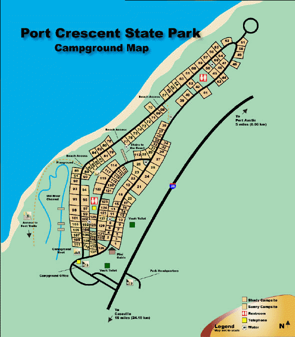
Click here to download a nice printable map (Adobe pdf) of the Port Crescent State Park which you can print.Click here to display a large version (one that you can actually read) of the Campground map shown below. You can print the map by right-clicking on it and selecting print.
Commentary
Verizon service is okay.One new restroom building and one old one which is okay.
Some sites are paved. Mostly shady. Great beach. Beach sites are too sandy for tent stakes.